Cities can plan using maps showing areas that are vulnerable to flooding, say UC scientists
Rapidly falling rain can overwhelm storm drains and cause flooding. Windy rainstorms drenching the San Francisco Bay Area occur on average once a year, but over the past 30 years these storms have become wetter and more frequent.
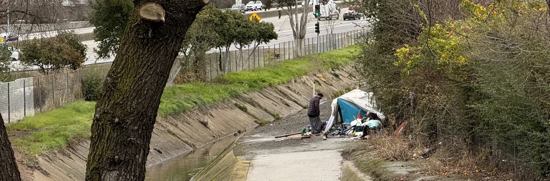
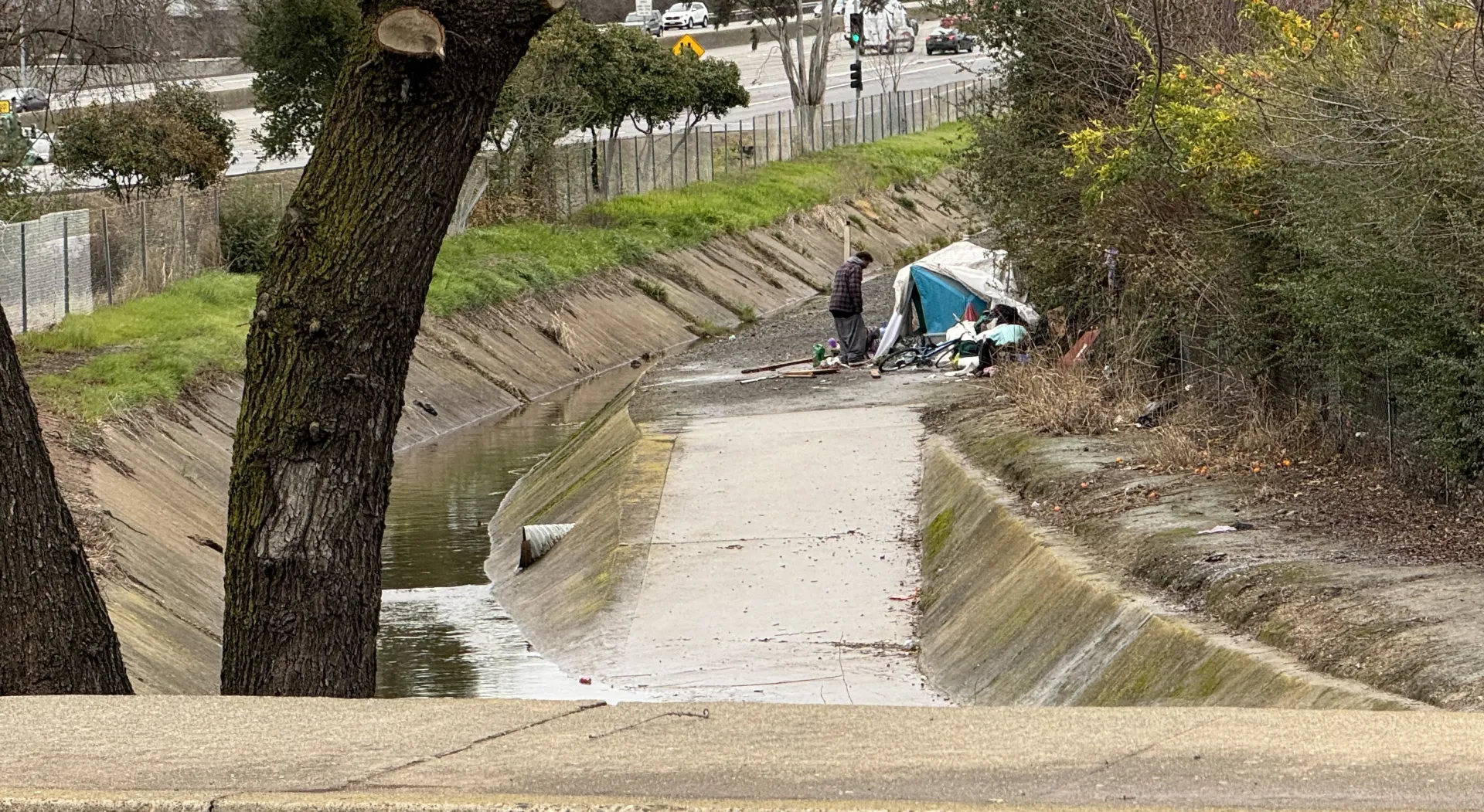
Rainstorms are increasingly dangerous for homeless people living near rivers and streams, according to University of California scientists.
“Windy rainstorms will become rainier as the climate warms, which means that flood risks will increase,” said Igor Lacan, UC Cooperative Extension environmental horticulture and urban forestry advisor for the Bay Area. “This is a concern for homeless people living in or near urban stream corridors.”
Nikhil Kumar, a hydroclimatologist, worked with Lacan and UC Davis professor Gregory Pasternack to study the impact of the wetter storms on some of the Bay Area’s most vulnerable communities. Using data from the Social Vulnerability Index created by the Centers for Disease Control’s Agency for Toxic Substances and Disease Registry, they mapped the vulnerability of each Bay Area census tract across four socio-economic themes – socioeconomics, household status, minority populations and housing/transportation.
Maps show vulnerable patches of Bay Area
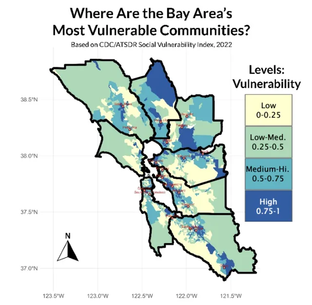
In the Bay Area, some areas are more vulnerable, where “social vulnerability such as sensitivity to hazards based on low income and resources overlaps with higher storm frequency,” Lacan said. “These areas are patchily distributed across the Bay Area counties and include both urban stream locations such as in San Jose and Hayward and more ex-urban streams as you see in Antioch and Vallejo.”
Their research reveals areas where additional resources may be most needed, and where timely warning of incoming storms is most critical to ensure people who camp near creeks and rivers are safe from floods.
Some coastal urban areas, including Richmond and Oakland, experience less frequent storms, but are home to more vulnerable residents.
“As people work on planning for climate change, they should take into consideration the people and places that are most vulnerable, who have the least ability to cope with extreme storms,” Pasternack said. “People living unsheltered are those most vulnerable.”
Kumar, Pasternack and Lacan have created a Bay Area map that shows areas where vulnerable residents are most exposed to flooding from rainstorms.
“While all areas need to plan accordingly, special attention is needed in the areas in red in the map,” Pasternack said. “Moreover, within those red patches, locations that are encampments are the most at-risk.”
Some of these high-risk areas are inland, such as in Concord, Santa Rosa and Vallejo.
“While some people are working hard to find homes for folks in encampments, meanwhile the number of people losing their housing is still growing, so the problem is trending worse,” Pasternack added. “Therefore, we need to take steps to provide support for people where they are, even as we work to move them into better solutions for the long term.”
Daniel Swain, a climate scientist with UC Agriculture and Natural Resources, studies how extreme weather is changing as global temperatures rise.
“The heaviest downpours in a warming California will become even more intense, and that's likely going to increase the risk of flooding in urban areas and along the creeks, streams, and rivers that flow through them,” said Swain, who was not involved in this flooding risk study.
“Knowing in advance which areas have an especially high overlap between storm-related inundation risk and highly vulnerable populations can help pinpoint where targeted interventions are most needed to ensure public safety, both today and in a warmer future climate,” Swain said.
“This is especially true in situations where rising water levels may take people by surprise, which can occur not only during the most intense storms but also when heavy rain events occur suddenly or at an unusual time of year,” Swain added. “This can be a real danger for those living and working in or near concrete-lined urban flood channels, as these are designed to move large volumes of water much more quickly and with greater force than a natural stream or river would.”
Lacan, Kumar and Pasternack have co-authored fact sheets with maps of vulnerable areas and tips for protecting residents. The fact sheets can be downloaded for free at Lacan’s website: https://ucanr.edu/site/igors-urban-website/urban-streams-storms-and-homeless-populations. For free copies of the maps, email Pasternack at gpast@ucdavis.edu.
Policy implications
To plan for more frequent and intense damaging rainstorms, Lacan and Pasternack suggest the following:
- Risk awareness: such as timely flood alerts;
- Decision-making and cost-benefit analysis: such as investing in more storm drain maintenance and clearing debris from stream corridors;
- Prioritization of efforts: before major storms, homeless people camping in stream corridors may need to be relocated;
- Long-term adaptation: increased rain rates will affect both our water-management system and natural stream habitats and urbanized ecosystems.
The article “Socio-Economic Risk of Rising Compound Precipitation-Wind Extremes in San Francisco Bay Area” was published in the International Journal of Climatology at https://doi.org/10.1002/joc.70120.
This research was supported by Climate Action 2023 Seed Awards of the University of California Office of the President, USDA National Institute of Food and Agriculture, Hatch (project numbers CA-D-LAW-7034-H and CA-DLAW2620-H) and North Santa Clara Resource Conservation District.